A blog post by ASTRIAL
In today's data-driven world, the ability to extract actionable insights from vast streams of information in real-time is becoming increasingly crucial. Across various domains - be it transportation, emergency response, environmental monitoring, or crime - where events unfold within specific geographic confines and defined temporal windows, traditional data processing approaches frequently prove inadequate. This is where Geo-Spatio Temporal Complex Event Processing (G-CEP) engines step in, offering a sophisticated solution to analyze complex events with spatial and temporal attributes.
G-CEP is a specialized software system designed to process, analyze, and correlate complex events occurring within a defined geographic area and time frame. It combines elements of complex event processing (CEP) with geospatial and temporal awareness, enabling it to detect patterns, trends, and anomalies in real-time data streams. Spatiotemporal event detection serves as a gateway to enable a better understanding by detecting events that represent the abnormal status of relevant phenomena. These events require monitoring and detection with high accuracy and reliability in content, location, and time to facilitate decision support.
Utilising G-CEP within APPRAISE
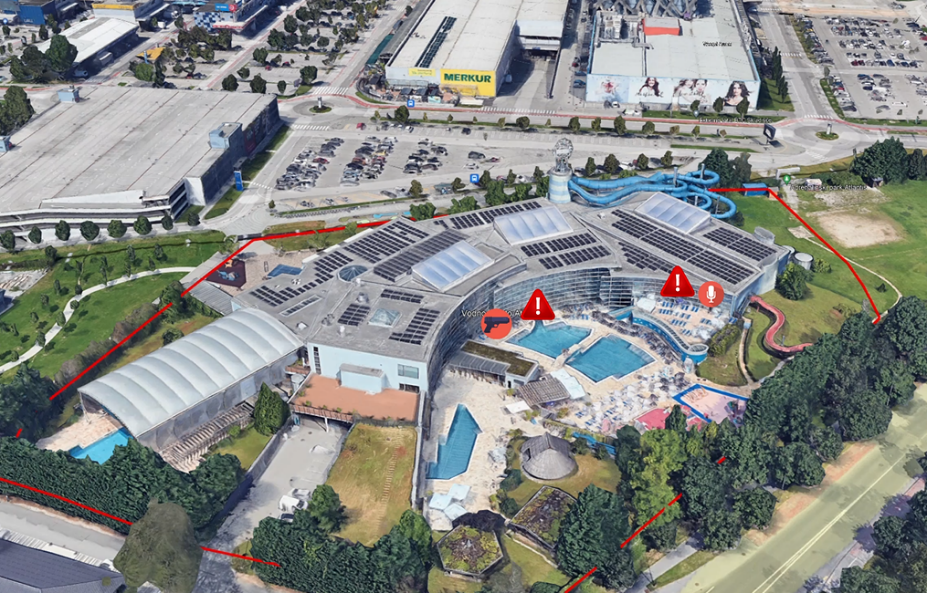
In addition to its broader applications, G-CEP engines serve critical roles in specific ecosystems tailored for advanced threat detection and response. The integration of G-CEP within the APPRAISE ecosystem plays a pivotal role in processing low-level threat alerts and translating them into actionable insights for law enforcement agencies (LEAs). G-CEP serves as the backbone for processing and correlating a multitude of low-level threat alerts detected by various sensing tools. These alerts, stemming from diverse sources, are ingested into the G-CEP engine, which then applies user-configurable spatio-temporal rules to correlate them effectively. The resulting high-level threat alerts are then seamlessly pushed to a map-based visualization platform, empowering LEAs in real-time.
The correlation rules implemented in G-CEP encompass several key dimensions, enabling sophisticated analysis and pattern recognition:
- Location (Polygon): Users define specific geographic areas of interest, allowing G-CEP to focus on events occurring within designated regions.
- Time (Interval): Time intervals specified by the user enable G-CEP to consider events within defined temporal boundaries.
- Sensing Input (Type of Detection and Sensor ID): Users can select which sensors and types of detections to consider, tailoring the analysis to specific threat scenarios.
- Confidence Level (% Reliability of Result): G-CEP allows users to specify the reliability threshold, ensuring that only alerts meeting certain confidence levels are considered for further processing.
This rule-based method provides the capability to capture important information about the topic, location, and time of an event, especially when dealing with many noisy datasets. This approach is particularly suitable for automating domain knowledge and reducing the labor of manual investigations.
Workflow in the APPRAISE framework:
- Processing Low-Level Alerts/Threats: G-CEP ingests low-level alerts and threats received from various detection tools within the APPRAISE ecosystem, encompassing a wide range of threat scenarios.
- Correlation and Rule Application: Applying user-configurable rules, G-CEP correlates these alerts based on their spatial and temporal attributes, thereby creating high-level threat alerts that encapsulate broader patterns and trends.
- Visualization and Actionability: The resulting high-level alerts are seamlessly pushed to a map-based visualization platform, where LEA operators can intuitively interpret and act upon the synthesized intelligence.
In essence, G-CEP within the APPRAISE ecosystem, developed by ASTRIAL GmbH, exemplifies the transformative power of Geo-Spatio Temporal Complex Event Processing in enhancing threat detection capabilities and empowering law enforcement agencies with timely and actionable insights.
Copyright: ASTRIAL GmbH
In an era defined by the rapid generation and dissemination of data, the ability to process, analyze, and derive actionable insights from complex events occurring in both space and time is paramount. Geo-Spatio Temporal Complex Event Processing engines represent a powerful tool in the arsenal of decision-makers across various domains, offering the capability to unlock valuable insights and drive informed decision-making in real-time. As technology continues to advance, the GCEP engines will play an increasingly central role in harnessing the wealth of data generated by interconnected devices.