A blog post by ASTRIAL
The demand for surveillance and visualization in a 3D model of soft target sites, coupled with the detection and tracking of objects, along with real-time event recognition using Unmanned Aerial Vehicles (UAVs) such as drones, has seen a significant rise in applications across civil, law enforcement, security, defense operations, and in the management of large infrastructures namely highways and energy sites.
With the rapid advancements in deep learning, increasingly powerful AI tools capable of learning semantic, high-level features are being employed to meet evolving demands. Robust UAV-based wide-area surveillance systems, equipped with onboard geo-localization modules and autonomous image-based detection capabilities, are being developed. These systems aim to be widely implemented for the prevention and management of terrorist incidents or attacks against critical infrastructure and soft targets, showcasing their effectiveness in addressing contemporary security challenges.
Recent progress in drone technology has resulted in enhanced capabilities, particularly in terms of extended flight time, increased payload capacity, and improved image resolution. These advancements have broadened the scope of drone applications significantly. For instance, drones equipped with thermal imaging cameras proved invaluable in search and rescue operations, facilitating the detection of individuals in challenging terrains or under low visibility conditions. High-resolution camera-equipped drones find utility in border patrol and wildlife conservation, enabling the efficient monitoring of expansive land areas with minimal human intervention.
Copyright: ASTRIAL GmbH
Furthermore, there has been a substantial improvement in the quality of computer-aided piloting software. This enhancement allows pilots to easily program autonomous flight paths through a user-friendly graphical interface. Automated functions enable drones to autopilot while real-time tracking of objects occurs. In-flight automation, coupled with advanced visual object recognition capabilities and improved sensors, empowers drones to target and track individuals or objects even from considerable distances. These technological strides collectively contribute to the versatility and efficiency of drone applications in various fields.
Developments within APPRAISE
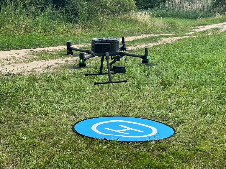
Within the scope of the APPRAISE project, we leverage a cutting-edge UAV platform and advanced visual cameras to enhance specific functionalities, including rapid generation of updated 3D models for soft targets, detection of abnormal behavior exhibited by individuals and vehicles, localization and tracking of identified threats. We customized the real-time streaming of surveilled areas to external platforms, integrating seamlessly with command-and-control systems and critical infrastructure information management systems with the use of video management platforms. This customization optimizes the utilization of drone technology for effective monitoring, alerting, and management within the project's objectives.
The process of generating 3D models entails utilizing UAVs to capture images, creating corresponding point clouds of an area, and subsequently employing this data to construct a 3D model of the environment. This technique, known as photogrammetry, finds applications in mapping, surveying, or simply visualizing a designated area accurately in a three-dimensional model. The latter approach provides a comprehensive representation of a specific area's layout.
When coupled with additional layers of information, such as semantically georeferencing virtual or real objects, it significantly enhances the perception of monitoring or surveillance capabilities. In the context of the APPRAISE project, we have successfully addressed multiple challenges associated with this process. This includes the substantial reduction of processing time required for the generation of high-resolution 3D reconstructions, the swift collection and annotation of diverse datasets, and the effective handling of dynamic environments. These achievements contribute to the project's ability to create detailed and accurate 3D models, essential for enhancing monitoring, surveillance, and overall situational awareness.
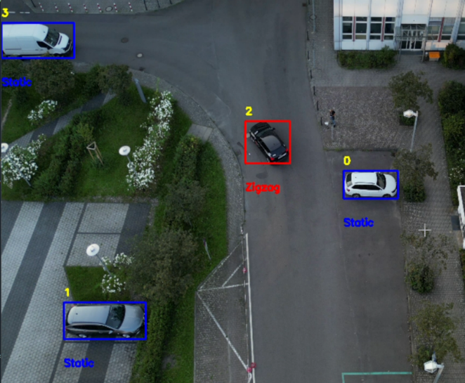
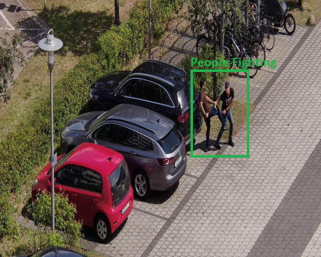
Identifying abnormal behavior using drones involves deploying the drone platform as a carrier for visual sensors. These sensors, combined with specialized image processing techniques, enable the recognition of behaviors that deviate from the norm in specific contexts. Such behaviors may include actions that are violent, dangerous, or deemed suspicious. In the APPRAISE project, a series of profiles were developed and rigorously tested in pilot scenarios. These profiles encompassed a range of activities, including people running, lying down, fighting, and entering restricted areas. Additionally, abnormal vehicle movements such as zig-zagging and unauthorized entry into restricted zones were processed. Object and event detection was reported coupled with precise localization and tracking, through the issuance of alerts that included positioning information. The validation process ensured increased accuracy and precision in object localization, contributing to advancements in the state-of-the-art within this domain. Simultaneously, these developments furnished users with high-quality actionable intelligence, further underscoring the project's commitment to enhancing capabilities in abnormal behavior recognition using drone technology.
Copyright: ASTRIAL GmbH
Watch the video to find out more
Benefits for the protection of public spaces
The innovative advancements in UAV technology within the APPRAISE framework yield numerous benefits for safeguarding public spaces. Key features include:
- Customizable Real-time Streaming: The ability to easily tailor real-time streaming of the surveilled area enhances adaptability and responsiveness to dynamic situations.
- High Accuracy and Confidence in Abnormal Activity Detection: The technology ensures precise and confident detection of abnormal activities involving individuals and vehicles within a 2x2 km surveillance area.
- Real-time Semi-autonomous Localization and Tracking: The system facilitates the immediate and semi-autonomous localization and tracking of objects engaging in abnormal activities, enhancing the efficiency of surveillance efforts.
- Quick Generation of Updated 3D Models: The rapid creation of updated 3D models for the surveilled area aids in maintaining accurate and current spatial information, contributing to effective monitoring and situational awareness.
These features collectively enable:
- Effective Monitoring and Surveillance: The technology enhances the overall effectiveness of monitoring efforts, ensuring a comprehensive understanding of the surveillance area.
- Live Streaming of Incidents: Real-time streaming capabilities allow for immediate awareness and response to ongoing incidents, fostering a proactive approach to security.
- Prevention of Physical Attacks on Critical Infrastructures: By identifying abnormal activities in real-time, the system contributes to preventing potential physical attacks on critical infrastructure.
- Support for Investigations and Prosecution: The recorded data and real-time information serve as valuable evidence, supporting investigations and aiding in the prosecution of individuals involved in unlawful activities.
- Facilitation of Effective Forensic Examinations: The technology streamlines the examination of seized drones, contributing to efficient and thorough forensic analyses.
In summary, the APPRAISE framework's UAV technology, developed by ASTRIAL GmbH, represents a comprehensive solution for enhancing public space protection, providing a versatile and sophisticated toolset for monitoring, incident response, and security management.